Publisher's Synopsis
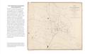
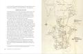
What is a 'drink map'? It may sound like a pub guide, yet it actually refers to a type of late nineteenth-century British map designed specifically to shock and shame people into drinking less. This book explores how drink maps of particular cities were published in an attempt to fight increasingly rampant alcohol consumption, from Liverpool, Manchester and Sheffield to Oxford, London and Norwich. Featuring red symbols to indicate where alcohol was sold, these special street maps were posted prominently in public places, submitted as evidence, sent to Members of Parliament and published in newspapers to show just how inebriated a neighbourhood could be. They promoted the message that having fewer places to buy alcohol was the answer to reducing widespread crime, poverty and sickness. And they worked - at first. After consulting a drink map in one town, judges decided to close half the licensed shops because even then no one had to walk more than two minutes to buy a beer. Illustrated with original maps, advertisements and temperance propaganda, the story of their brief history is told amidst a tangle of licensing laws, rogue magistrates, irate brewers, ardent temperance organizers and accounts of the complex role alcohol played across all levels of Victorian society.